|
|
Post by V6-steam engine on Feb 3, 2019 11:27:11 GMT
So dudecp123 made a post about found concept map of Underground 2 ==> Post
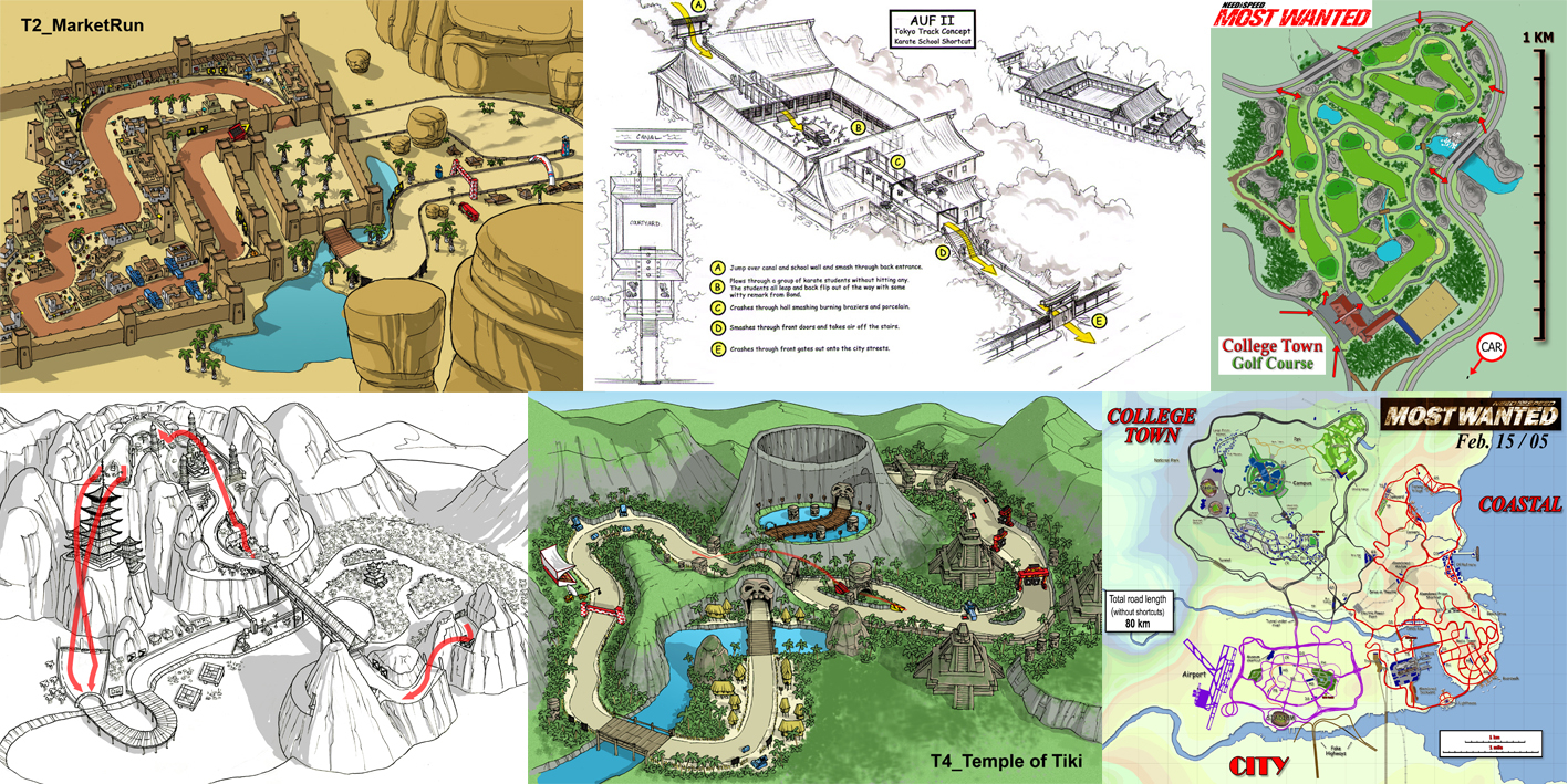
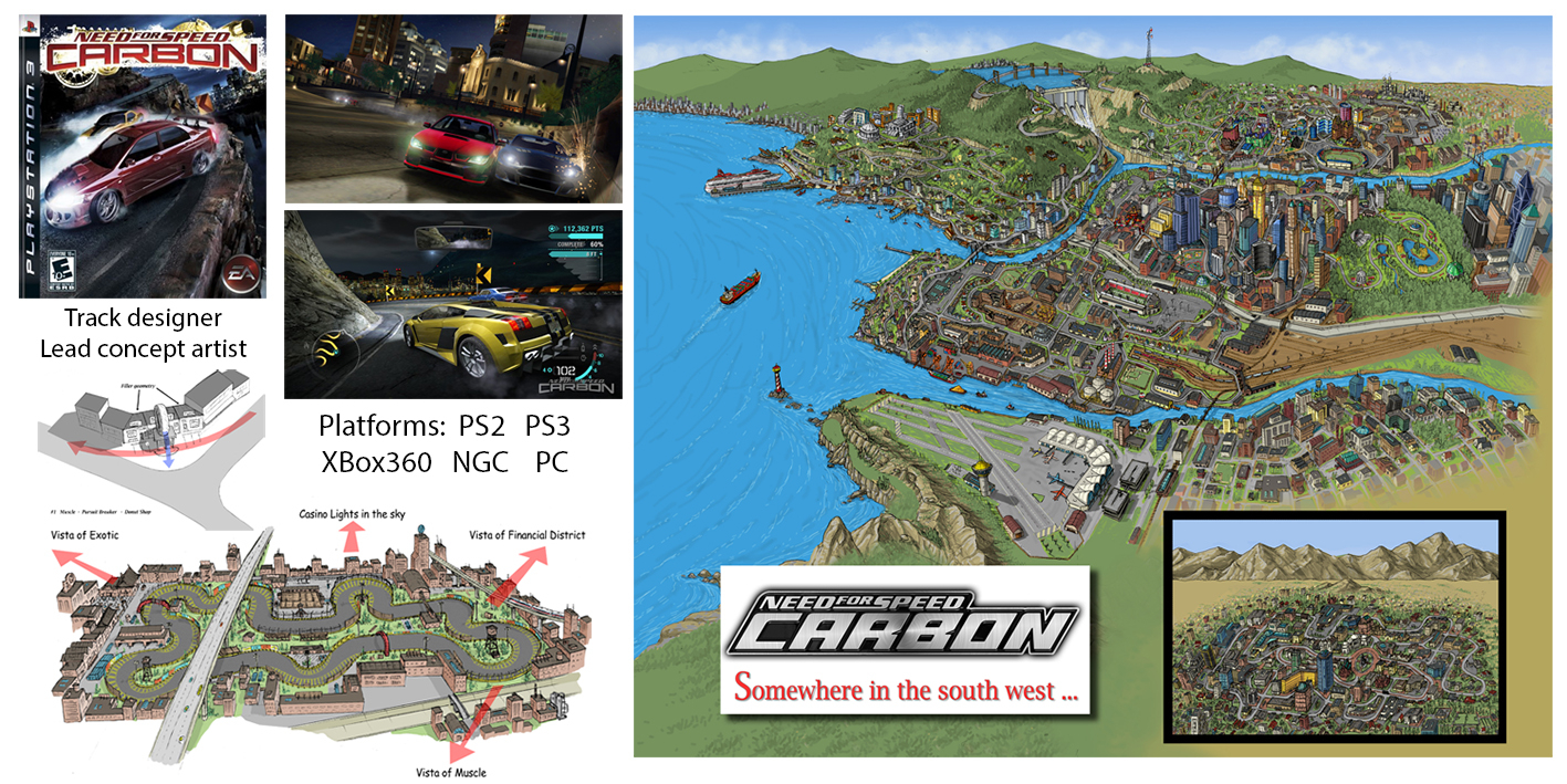
On the site there are two more interesting maps: A low resolution early Most Wanted map (similar from the Black edition DVD's background - Contains an Airfield) (Also Old Logo(?))  And a draw art for Carbon - Comparison needed  All credits to dudecp123's post. |
|
|
|
Post by GT3 on Feb 3, 2019 23:36:30 GMT
In the Carbon map, not only am I seeing the airport in Kempton as well as the separate picture of what we assume to be San Juan but I can also see the infamous mystery city behind Fortuna.
|
|
|
|
Post by dudecp123 on Feb 4, 2019 2:35:54 GMT
More stuff and higher definitions of some photos can be found here (thanks to gRiM, who found it): Carbon Worldmap (dated May 2006): Most Wanted Worldmap (Dated Feb 2005):
MW Golf Course: Carbon Drift Track Concept: MW Drift Track Concept: Camden Beach Concepts:
Carbon Concept (Alternate Logo):
|
|
|
|
Post by Blackweed on Feb 4, 2019 4:16:11 GMT
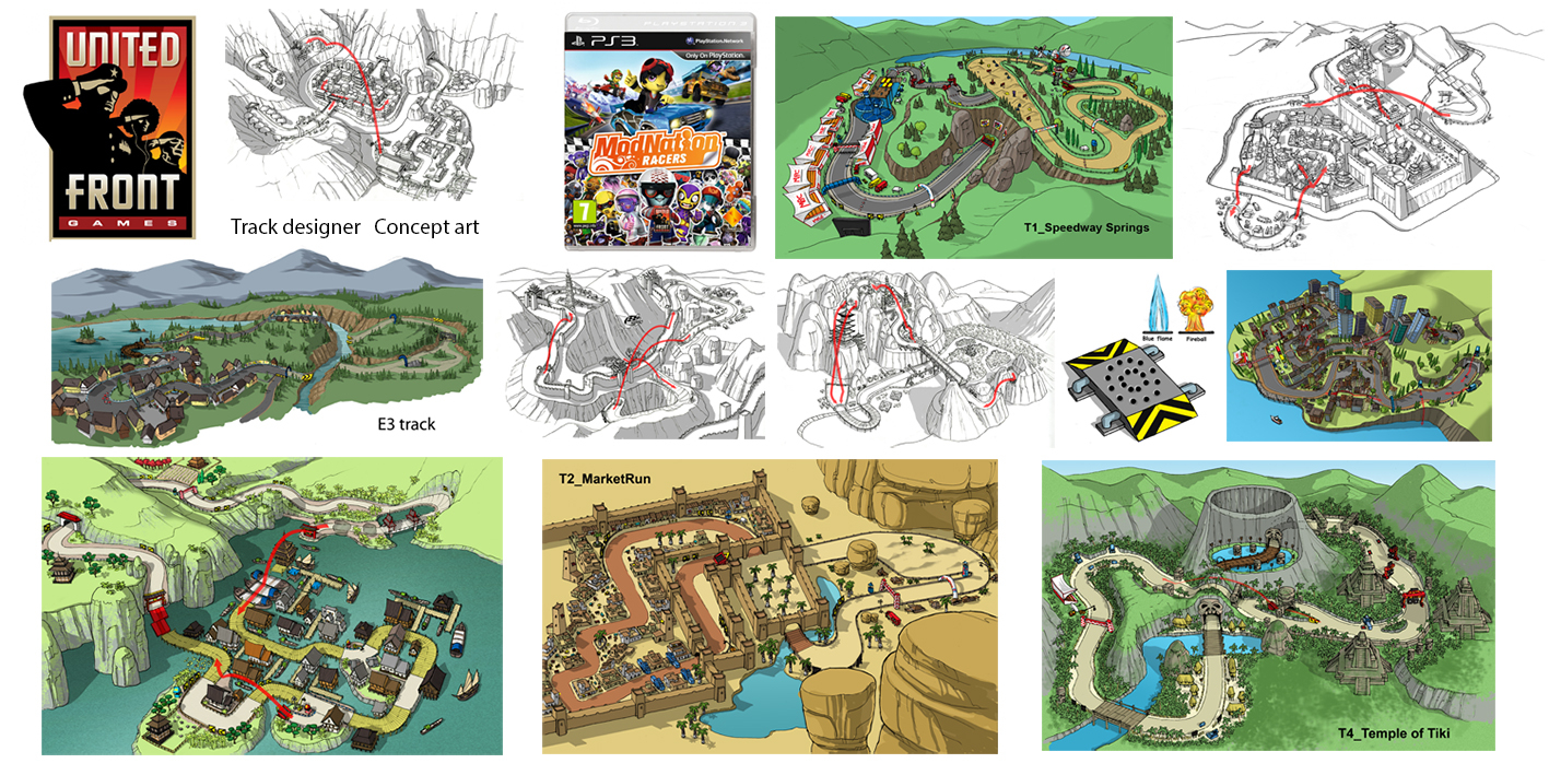
Some of the concept arts in the first picture look like they're straight out of Asphalt.
|
|
|
|
Post by NEO_NoiseBomb on Feb 4, 2019 5:02:58 GMT
Market Run, Tokyo Track, Temple of Tiki and unnamed Far Eastern track. What were MW 2005's earliest plans? Something has made BB decide to ditch whatever this concept/plan was and go for mixing UG and Hot Pursuit and thus the final product we got.
Also, I like that Carbon map concept. You can still most (maybe) all of the landmarks that appear in the final game such as Chinatown, Downtown Palmont Park, The Dam, Palmont University and much more.
|
|
|
|
Post by dudecp123 on Feb 4, 2019 7:20:21 GMT
Market Run, Tokyo Track, Temple of Tiki and unnamed Far Eastern track. What were MW 2005's earliest plans? Something has made BB decide to ditch whatever this concept/plan was and go for mixing UG and Hot Pursuit and thus the final product we got. Also, I like that Carbon map concept. You can still most (maybe) all of the landmarks that appear in the final game such as Chinatown, Downtown Palmont Park, The Dam, Palmont University and much more. Some of those in the first image are not from Most Wanted, It's from this game:  |
|
|
|
Post by nfslover on Feb 4, 2019 11:49:54 GMT
Huge findings! I'm still pretty sad BB cut the Airport from MW, it would have been a lot of fun to explore with Debug Cam. So the Drag Race Mode seemed to be similar to UG2 until at least until mid Feb '05.
|
|
|
|
Post by Deleted on Feb 7, 2019 15:12:59 GMT
I just noticed something, the center of Downtown Rockport resembles Bayview's City Core!
|
|
|
|
Post by ∞zhrizz∞ on Feb 10, 2019 16:25:19 GMT
I’m wondering if the area with the Airport I the Carbon pic is supposed to be Kempton or just another area further south of Kempton (separates by the water)
|
|
|
|
Post by Blackweed on Feb 11, 2019 6:38:22 GMT
I’m wondering if the area with the Airport I the Carbon pic is supposed to be Kempton or just another area further south of Kempton (separates by the water) Doesn't seem to be. It has no roads leading to it. |
|
|
|
Post by LACooper on Feb 11, 2019 19:32:53 GMT
I’m wondering if the area with the Airport I the Carbon pic is supposed to be Kempton or just another area further south of Kempton (separates by the water) Doesn't seem to be. It has no roads leading to it. It looks to be south to Kempton behind the shipyards and cargo cranes, that area can be driven-by in the game in Kempton Maybe they have implented a 2D Airport image. |
|
|
|
Post by V6-steam engine on Feb 12, 2019 17:32:07 GMT
   Highlighting the roads reveals some interesting stuff: Note the dead ends in Kempton and the Channel, which goes underwater to Fortuna (!) and aslo connects to downtown. Also there is a road in Silverton that leads to nowhere. ALSO note some returning elements in their place or somewhere, fe: The radio in Silverton, the scenery view on fortuna, the S highway harpin ect. The drift concept track can be placed around the south side of the downtown park area: Channel checks, Vista of Financial District checks, Casino and Exotic with direction checks (tho i dont think you can see them much). Even the Downtown elevated train checks. The highway do not check, but since in the final track either, i think its alright. About the airport: I personally think it was dropped a bit later, since the Offical map still shows the South Canyons (Which is strangely not named in any way) and the whole "island" being close to the Kempton, but in game it leaves a ton of space between them. What is inetersting on this map, is that not even a canyon concept is seen. No mountains on the East, not in the West and "Carbon" canyons, not even around the lake, but it has the city on the other side of it, so it is strange considering the rumor that they wanted to include it drivable, originally. This raises the question: If this map is made in 2006 (signed on the right side, following the channel) how did the Demo map came up? I mean, that is an ingame ready (please exclude lookout point) map with hideouts, shortcuts and almost everything. I just cant fit that into a developement time. What we (or at least I) need to know is when that map was created/put into the demo game (with the final map included secretly, it is really confusing). (( The May 2006 map, which was uploaded by dudecp also says "Drift" with 64km of tracks. Drivable World and "Drift" is 161 kms. Is it possible that the Drift track and the Canyons sum up a total of 64 kms?? )) |
|
|
|
Post by LACooper on Feb 12, 2019 22:46:23 GMT
In the demo the map is a placeholder since the available races were also available in the final city layout they didn't have to change the map in the menu.
The Demo map in the menu is problaby from a very beginning of a later concept, since it consists of the final Palmont districts layout, San Juan and canyon roads but just in a different layout order.
The actual races in the demo take place in the final Palmont City already, just the menu map is outdated.
The concept map above already shows the final Palmont design and layout, even San Juan is separated as a small town in the desert.
Yes, it is possible if a single track is 5 miles long it is over 11 Kilometers already.
There are mountains in the west and north, south and east can't be seen much but south edge reveals cliffs.
Those 'dead end' roads in Silverton don't go nowhere, they simply pass behind the mountain (curve) so from that angle you can only see what would be in sight, the roads re-appear in front of the mountains again.
|
|
SpeedY
Community Manager   AAAAAAAAAAAAAAAAAAAAAAAAAAAAAAA
Public Download Section Is UP!
Posts: 2,730
Mini-Profile Background: {"image":"https://cdn.discordapp.com/attachments/205152173577732097/215564809322758144/nfsciwanttobelieve.jpg","color":"bdbdbd"}
Mini-Profile Name Color: ff00d6
Mini-Profile Text Color: 000000
|
Post by SpeedY on Feb 23, 2019 18:05:18 GMT
the demo map (and andersonway) were probably just concepts used as placeholders by the ui designers(no point in switching placeholder concept maps / concept race texutures mid way developing a ui)
"drift" being 64km doesn't make any sense. although its probably all canyons and a mess of measuring the drift course? maybe it also includes that cut "raceway" thingy
|
|